
Show all 19 posts from this thread on one page
|
Show all 19 posts from this thread on one page |
UKC Forums (http://forums.ukcdogs.com/index.php)
- UKC Coonhounds (http://forums.ukcdogs.com/forumdisplay.php?forumid=4)
-- Garmin 320 Birdseye View Question (http://forums.ukcdogs.com/showthread.php?threadid=464231)
Garmin 320 Birdseye View Question
Looking at getting a Garmin 320, have a question about the Birdseye Satellite View. How does it compare to looking at GoogleEarth? I'll be using it in an area with almost no roads that would be marked on a Topo map, so I need the Birdseye view to do me any good....
Is the Birdseye View pretty clear? And can you zoom in like with GoogleEarth, to where I can see groups of trees and very small dirt roads?
I can't imagine how much easier my hunting would be if I had something comparable to GoogleEarth in my hands in the woods.....
Yes, it is very similar to Google Earth
It works really great in combination with the topo card. Keep in mind that your Garmin screen is smaller in size, but the images are pretty clear. I can watch the dogs work around a field and I can see a group of trees in the corner. I can watch the pointer as they enter them and see if they blow right on through or work around it. After using it, I would hate to go back to watching a 220 screen. Another nice thing is the blue lines showing streams on the topo card may not be exactly where the stream really is and BirdsEye is right on. The downloads are probably 3 to 5 years old, so it may show a fence that has been pushed out that is not there anymore, or a new house that has been built since.
__________________
OFFICIAL FIELD TESTER FOR LEMS LIGHTS
Good people do not need laws to act responsibly, while bad people will find a way around the laws (Plato)
Re: Yes, it is very similar to Google Earth
quote:
Originally posted by Tim MACHA
It works really great in combination with the topo card. Keep in mind that your Garmin screen is smaller in size, but the images are pretty clear. I can watch the dogs work around a field and I can see a group of trees in the corner. I can watch the pointer as they enter them and see if they blow right on through or work around it. After using it, I would hate to go back to watching a 220 screen. Another nice thing is the blue lines showing streams on the topo card may not be exactly where the stream really is and BirdsEye is right on. The downloads are probably 3 to 5 years old, so it may show a fence that has been pushed out that is not there anymore, or a new house that has been built since.
Re: Re: Yes, it is very similar to Google Earth
quote:
Originally posted by JRS7
WOW!! Time to dig into savings.......
Am I correct in the assumption that the images are the exact same ones that GoogleEarth uses, with only the limitations of the smaller screen on the Garmin changing them at all? (Can't imagine that there are more than one set of photos of the entire earth floating around....)
Sitting here looking at GoogleEarth, can't imagine how cool it would be to 'see' my dog going across the map, through the trees, across the river, ect. I don't think much changes where I hunt, the maps would be pretty accurate.
I can hear myself now: "Honey, I know I spent a lot on the dog, but this Garmin thing would make it so much easier. I might even get home earlier." (Fingers crossed behind my back on that one......)
__________________
OAKS POINT KENNELS
HOME OF
PKC CH GRNITECH GRCH 'PR' OAKS POINT COON BUSTIN' BELLE HTX 2013 UKC Top 100 (May 2006-January 2017)
'PR' OAKS POINT STRIKE-EM OUT BEAU (May 2006-June 2016)
PKC CH NITECH GRCH 'PR' COON BUSTIN' WHITE STUFF
CH 'PR' GOLD RUSH EXPO
'PR' BLACK KNIGHT'S BALU JETTA (May 2013-October 2015)
CH 'PR' CHERRY CREEK XBOX 2016 Treeing Walker Days King of Show
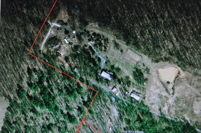
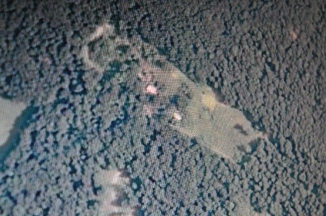
The Images that I have Compaired the BirdsEye are New Photos compaired to Google Earth .. When I look down at Google it Shows a Camper Trailer we Sold in 2008 .. and the BirdsEye Shows a OverGrown Are where it used to be and By what I can tell by other Items is that This Image could be From this Summer.. Google Earths Image of the Same area is dated Jan. 1st 2007
Google 2007 Image
BirdsEye Image
__________________
Steve Morrow "Saltlick Majestic's"
"Never Have Hounds Or Kids And You Won't Get Your Heart Broke"!!
540-421-2875
PR, Saltlick's Blue Misty Linga "Bluetick Coonhound"
French X American Hounds
garmin astro 320
i just purchased a new astro 320... how do u get to the birds eye view on here? its my first garmin....is their any other features i would need help on finding or using?
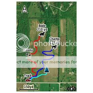
I took 6 puppys for a walk yesterday and Put the Collar on one of my older hounds ..
This Is what it shows with the Track on the BirdsEye Image

Note The Red lined Dog Trail was 2.79 Miles Long
VERY VERY Short Cell Video from that Walk with the Pups and Their Great Grand Hound
http://www.youtube.com/watch?v=-zaM8ZxiJXI
__________________
Steve Morrow "Saltlick Majestic's"
"Never Have Hounds Or Kids And You Won't Get Your Heart Broke"!!
540-421-2875
PR, Saltlick's Blue Misty Linga "Bluetick Coonhound"
French X American Hounds
Birdseye satellite looks just like Google maps. I just downloaded mine and only had astro 320 4 days.. It is the most amazing thing I have ever seen hit the coon hound world. This just takes hunting to a whole different level.
Birdseye
Majestic Tree H
I love the Birdseye, but I am sure Garmin could have made it clearer.
Is your pic of your puppy walk from computer ?
I would like to see comparison of same pic on Astro.
I've downloaded Birdseye 10 times on Mini-SD Card & 3 times on Astro & have no where near the clarity of your puppy walk pic.
The image of where your camper was is more like my maps,
I know Garmin says Astro screen is small & images just have so much clarity, but my son has a phone he put Googlearth on & amazing clear image, & his screen is just a little bit bigger than Astro. A game warden here has a Garmin hand-held (Rhino ?) that has birdseye maps much more clear than Astro.
David
__________________
NT CH "PR" Turkey Creek Playboy
Dual Grand Ridgeway's Deep Creek Zena
Dual Grand Laurel Fork Mongo
Grand Night Tight as a Cord
That Photo is from the BaseCamp Program .. Now buy What I've been told is that the Images Used for the BirdsEye area Taken from a Satelite thats Out about 120 Miles High .. Google Images are Taken out about 40 Miles .. So their is a Great Difference in the Resilution ..
Google Uses 4 Imaging Satelites in a Quad Pattern Orbit so their Producing a QuadraPhonic 3D Image
__________________
Steve Morrow "Saltlick Majestic's"
"Never Have Hounds Or Kids And You Won't Get Your Heart Broke"!!
540-421-2875
PR, Saltlick's Blue Misty Linga "Bluetick Coonhound"
French X American Hounds
Re: Re: Yes, it is very similar to Google Earth
quote:
Originally posted by JRS7
WOW!! Time to dig into savings.......
Am I correct in the assumption that the images are the exact same ones that GoogleEarth uses, with only the limitations of the smaller screen on the Garmin changing them at all? (Can't imagine that there are more than one set of photos of the entire earth floating around....)
Sitting here looking at GoogleEarth, can't imagine how cool it would be to 'see' my dog going across the map, through the trees, across the river, ect. I don't think much changes where I hunt, the maps would be pretty accurate.
I can hear myself now: "Honey, I know I spent a lot on the dog, but this Garmin thing would make it so much easier. I might even get home earlier." (Fingers crossed behind my back on that one......)
__________________
OFFICIAL FIELD TESTER FOR LEMS LIGHTS
Good people do not need laws to act responsibly, while bad people will find a way around the laws (Plato)
Majestic, what resolution do you use? I downloaded in highest but think maybe a lower setting would be just as good and would be able to have more map.
__________________
Ignorance: the lack of knowledge, education, etc.
Stupidity: lacking normal intelligence.
Intelligence: the ability to learn or understand.
You can't fix STUPID!
I'v been downloading it in the Highest Res. .. I tried one in High and Did'nt like it but it could be useable
__________________
Steve Morrow "Saltlick Majestic's"
"Never Have Hounds Or Kids And You Won't Get Your Heart Broke"!!
540-421-2875
PR, Saltlick's Blue Misty Linga "Bluetick Coonhound"
French X American Hounds
Re: Yes, it is very similar to Google Earth
quote:
Originally posted by Tim MACHA
It works really great in combination with the topo card. Keep in mind that your Garmin screen is smaller in size, but the images are pretty clear. I can watch the dogs work around a field and I can see a group of trees in the corner. I can watch the pointer as they enter them and see if they blow right on through or work around it. After using it, I would hate to go back to watching a 220 screen. Another nice thing is the blue lines showing streams on the topo card may not be exactly where the stream really is and BirdsEye is right on. The downloads are probably 3 to 5 years old, so it may show a fence that has been pushed out that is not there anymore, or a new house that has been built since.
Mine may not show as much green
but it is almost as clear. I guess what I am looking for is to know what kind of land my dog is on, whether open field or woods. I am not looking to take a picture. lol
__________________
OFFICIAL FIELD TESTER FOR LEMS LIGHTS
Good people do not need laws to act responsibly, while bad people will find a way around the laws (Plato)
Re: Mine may not show as much green
quote:
Originally posted by Tim MACHA
but it is almost as clear. I guess what I am looking for is to know what kind of land my dog is on, whether open field or woods. I am not looking to take a picture. lol
 ....Allthough I would respectfully disagree, of the two pics he shows of his house, the GoogleEarth one is quite a bit better to me......
quote:
Originally posted by Majestic Tree H
I'v been downloading it in the Highest Res. .. I tried one in High and Did'nt like it but it could be useable
quote:
Originally posted by CooperCreek
Maybe different areas of the country have bigger difference between high and highest, based on sources of imagery.
__________________
Let's go huntin
Part of track from Friday night's hunt
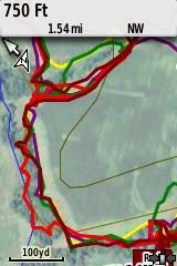
Yellow is my track. Lighter red is my Leopard, dark red is a young red dog, purple is my BMC, and green is a 5 month old red pup. You can see the tree line on the left side of screen and the buffer strip around the field.
So, I can see that the dog with the light red track went into the trees and worked through it and the other dogs just skirted the outside. With the old screen, I would have no way of knowing that only one dog actually went through the trees on the other side of the fence.
__________________
OFFICIAL FIELD TESTER FOR LEMS LIGHTS
Good people do not need laws to act responsibly, while bad people will find a way around the laws (Plato)
| All times are GMT. The time now is 04:40 PM. | Show all 19 posts from this thread on one page |
Powered by: vBulletin Version 2.3.0
Copyright © Jelsoft Enterprises Limited 2000 - 2002.
Copyright 2003-2020, United Kennel Club