Rip
UKC Forum Member
Registered: Jun 2003
Location: Morrison TN
Posts: 4927 |
quote:
Originally posted by Dogwhisper
I'm sure Garmin could do a better job w/their map cards.
After what I saw on the iphone and what I saw on the garmin display I would compare garmin map display to a comic book.lol.
GARMIN GET W/THE PROGRAM incorporate what the iphone has into the garmin system.
The Garmin maps are great. They are standard topo maps that are stored in your memory, and it just shows where the dog is on that map. The topo map doesn't take a great deal of memory especially compared to the sattelite maps.
The phones use the internet to access sattelite maps, too much info to store it. All that's great, but that's alot of info to try and get back from a collar to a hand held.
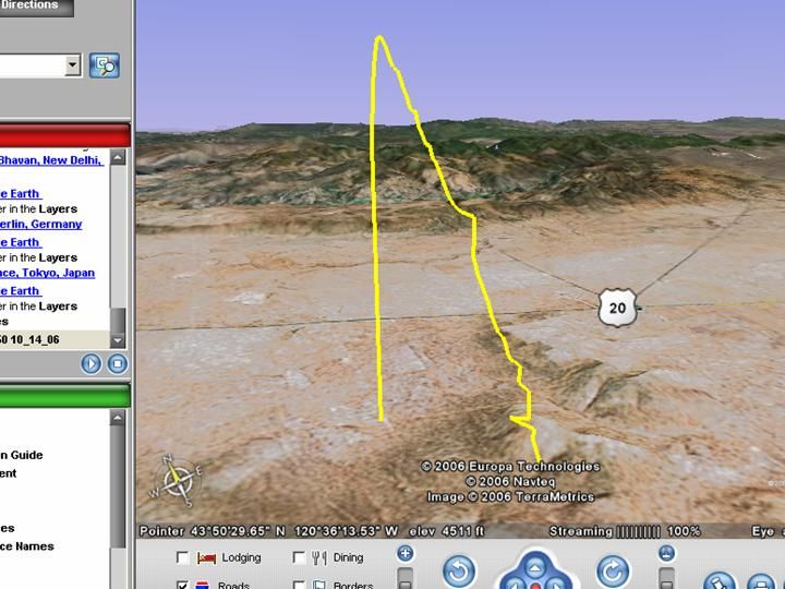
You can take your Garmin and put it on Google earth and see those pictures you were talking about, and see everywhere your dog went. It will show you in detail, he struck at the creek, took him up around the edge of the field then treed in the wet hollar. All that info is available to you now with the Garmin. It's just not available real time.
To get it real time they would have to be able to transmit and interpret all that information they do now (latitude of dog, GPS coordinates), access the internet and pull down the sattelite info and superimpose it on the map, and send it all back to the hand held. That's not easy to do.
__________________
Let's go huntin
Report this post to a moderator | IP: Logged
|


 11-28-2010 01:37 AM